VTS Communication Procedures

Procedure on VTS
Ships to be subjected to Traffic Service- Ocean-going ship for international route
- Ships over 300 tons for Gross Tonnage(But, except the inward fishing boats)
- Cargo Ships carrying dangerous goods as defined in the provisions of the Sea Traffic Safety Act, Article 2)
- Tug Boat with its towage line over 200 m
- Fishing boat with its length 45m or longer
- Towing vessel for construction work
- Oil tanker or Waste Oil Carrier with gross tonnage of 300 ton or less
- Passenger ship within a control area (But cruise ship within a port is excluded)
(Report on the conditions of ships) The shipmaster of the vessel subjected to VTS should make report on matters required for VTS business to the concerning VTS center according to the reporting procedure as follows, in accordance with the provisions set by the Enforcement Decree of the Public Order in Open Ports Act, Article 11.
- Report on expected entrance of a ship into VTS zone (10 miles before Reporting Line of Location): Vessel Name, Call Sign, and Estimated Time to pass the reporting line of position, Destination, Last departure port)
- Report on passing the line of navigationposition: Vessel Name, Time of passing, Destinations, Estimated time to enter the destination
- Report on arrival at destination: Vessel Name, Call Sign, Entrance Location, Time
- Report on expected movement (10 min before): Vessel Name, Location, Estimated Time of Movement
- Report on movement completion: Vessel Name, Call Sign, Location, Time
- Report on Expected Departure (10 min before): Vessel Name, Location, Estimated Time of Departure
- Report on Departure: Vessel Name, Location, Call Sign, Departure Time, Destination
- Report on passing the line of navigation position: Vessel Name, Time of Passing
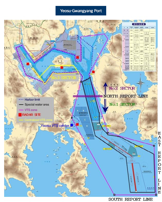
- South Reporting Line: N 34° 35′ 00",
- East Reporting Line E 128° 00′ 00”
- North Reporting line N 34° 48′ 26" (the line connection No.5 DW buoy and No.6 DW buoy)
| Sector 1 | South side of the VTS zone based on the North reporting line (located at N 34° 48′ 26" within VTS zone) |
|---|---|
| Sector 2 | North side of the VTS zone based on the North reporting line (located at N 34° 48′ 26" within the VTS zone) |
| Sector 3 | Sector 2: Area from Nak-po Port to Jungheung Port |
- VHF CH 12: Moving and Anchoring ships inside Sector 1
- VHF CH 67: Moving and Anchoring ships inside Sector 2
Channel change baseline North reporting line/Report on passing for entrance at CH67, for departure at CH12) - VHF CH 10: Supplemental channel or Port operation guide frequency within Sector 3)
- VHF CH 08/10/14/20/22/68 : VTS Operation Reserved Frequency
- VHF Uninstalled Ship : Mid-short wireless phone device SSB : 2,183.4khz/1,881.4khz
Any ship moving or anchoring inside the VTS zone that is subjected to VTSshould listen to the VTS operation frequency as well as Emergency frequency in use of very high frequency (VHF) wireless phone and etc. And for the ship not subjected to VTS should also open its VHF wireless phone to listen to the VTS operation frequency while sailing inside the VTS zone, so that it should take a route in order to avoid any interference to the navigation of other ships
Special VTS and Navigation Method- Any ship that is subjected to VTS, and entering or departing GS Caltex product port or GS VCM product port follow the direction of the VTS center.
- Any ship that is sailing within the port limit should keep to the optimal speed so as not to damage anchored ships or mooredships. In particular, ships sailing near Gwangyang Still Mill pier and GS Caltex crude oil pier should sail along aroute as far as possiblefrom those piers.
From the effective date (Jan.12, 2006) of the Amended Enforcement Decree of the Sea Traffic Safety Act which regulates the sea route and the navigation for the Special Water Area for Traffic Safety in Yeosu region, any ship which wants to enter to the port using the entrance route inside the speed limit zone of the special water area, should use the deep water navigation route until the time that a separate amendment of the same notification is made.
VTS Zone and Reporting Line of Position